SATELLITES
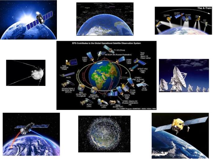
Satellites are a major part of everyday life.
Where would our Communications, and weather monitoring / prediction be without them?
Applications from Military to Civilian uses, our world is now fully connected thanks to the technology.
Aurther C Clarke was the first to describe Geostationary Satellites in a letter to the editor of Wireless World Magazine in February 1945 and further elaborated on this concept in a paper titled Extra-Terrestrial Relays – Can Rocket Stations Give Worldwide Radio Coverage?published in Wireless World in October 1945 which can be found below

|
extra_terrestrial_relays._clarke.wirelessworld._octubre_1945_6cf53078.pdf Size : 1718.457 Kb Type : pdf |
Eleven years later in 1956 Clarke wrote a letter to Andrew G. Haley. In it, he mentions the article in Wireless world and then expands on his earlier writings by correctly predicting the future development of both satellite television and GPS which can be read here ( 1 , 2 )
The geostationary orbit is now sometimes known as the Clarke Orbit or the Clarke Belt in his honour.
Although there is also mention of earlier ideas from others about communication satellites but they did name the orbit belt after him.
In 1962 NASA launched Telstar 1, the first communications satellite. Telstar 1 lasted only six months, but this paved the way for modern-day communications-there are nearly 900 active satellites in orbit today of which some two-thirds are communications satellites.
INFORMATION BELOWIS TO BE SORTED AND FURTHER RESEARCHED
Vanguard Group, State Street Corp., Fidelity and Black Rock.
United Technologies, Intel Sat, DirecTV via ATT, Loral Space and Communications, Northrup Grumman, Raytheon, Ball Aerospace and Technology Corp., Lockheed Martin, General Electric
FROM EMAIL DRAFT "SAT3"
Are Satellites a hoax?
This might seem far fetched but lets have a look.
Did you kniw that a balloon was our first Communication "Satellite"
http://www.space.com/8973-1st-communication-satellite-giant-space-balloon-50-years.html
The Military even use balloons called Aerostats for Boarder protection.
This type of Balloon is referred to as a "Persistent threat detection system" and is primarily used for a missile defense system.
http://www.lockheedmartin.com.au/us/products/lighter-than-air-vehicles/ptds.html
http://www.army-technology.com/projects/persistent-threat-detection-system-us/
It remains teatherd to a ground cable and actually got loose once.
http://www.dailymail.co.uk/news/article-3293852/Fighter-jets-track-military-blimp-drifting-Pennsylvania.html
http://www.foxnews.com/politics/2015/10/30/surveillance-balloon-program.html
This thing is what is NORAD uses to monitor for incoming missile attacks. Isn't that weird?
The aerostats are also used for on ground communications with troops in areas where comms are limited like Afghanistan.
I guess after spending $2B on a run away balloon they can't afford satellite phones to communicate with, I don't know, ALL THE SATELLITES THEY HAVE ALL ORBITING THE EARTH.
This article talks about how they couldn't use balloons or planes to relay signals which they usually do.
Now If the military can't get a satellite signal do you really think your phone or sports watch gets one?
And why are there black spots?
http://www.afcea.org/content/?q=troops-afghanistan-bridge-communications-gap-0
There is a long history of balloons in the military for communications.
Why do they have to use balloons like the tactical aerostats.?
http://m.military.com/NewContent/0%2c13190%2cDefensewatch_072105_Helms%2c00.html
http://www.tcomlp.com
And why use things like spy planes and drones to take images?
Why not just take a picture with a satellite which give even civilians the detail on things like Google Earth?
Aerostats were originally teatherd to the ground
http://fas.org/nuke/guide/usa/airdef/tars.htm
But are now being developed into a HALE-D so it will hover untethered at 70k ft and "will be used in conjunction with low flying aircraft" for comms and monitoring.
The Balloons are not being phased out by satellites either.
Lockheed Martin are assisting Google
with a fleet to get Internet access to remote areas in a program called "Google loon"
http://www.google.com/loon/
Facebook are planning on using drones for the same purpose.
Mark can't afford a satellite????
https://www.inverse.com/article/9851-mark-zuckerberg-says-solar-powered-internet-drones-coming-later-in-2016?utm_source=facebook&utm_medium=inverse&utm_campaign=organic
i think its odd that in 2016 companies as large as Google and Facebook would Consider using a balloon or drone when we already have all these satellites in orbit or could easily have their own.
How many Satellites are in orbit?
Appatently there are so many in Geostationary orbit that countries are fighting over orbital slots.
Disputes like this are addressed through the International Telecommunication Union's (ITU) allocation mechanism.
http://www.itu.int/net/newsroom/wrc/2012/features/satellite_regulations.aspx
This organization is owned by the U.N and has basically been trying to censor the Internet for years.
around every 3 years ITU have a meeting to discuss regulations for Telecommunications.
In 2012 The U.S voted out regulations proposed at WCIT-12 to prevent Internet control by ITU.
89 of 152 countries did sign the proposed regulations.
https://en.m.wikipedia.org/wiki/Geostationary_orbit
https://en.m.wikipedia.org/wiki/International_Telecommunication_Union
2012 doc
https://www.google.com.au/url?sa=t&source=web&rct=j&url=http://www.acma.gov.au/~/media/Spectrum%2520Engineering/Information/Word%2520Document/RALI%2520MS%252038%2520docx.docx&ved=0ahUKEwjWmqaqwPrKAhXJnJQKHU43D4sQFggdMAE&usg=AFQjCNHc5rA6AbIfPTNaRxK2GAayXNaSKQ&sig2=KVKB9VghQ3pnr5rU1_yI4A
In 2015 the ITU documemts had comments like this
"Navigation and safety at sea and in the air will feature in September and will include ITU's work in radar and satellite navigation as well as flight tracking in real time. On 24 September 2015, ITU will mark World Maritime Day to showcase the ITU Radiocommunication Sector's contributions to the world of shipping."
And
"The Conference will review and revise the Radio Regulations, the international treaty governing the use of radio-frequency spectrum and satellite orbits to ensure reliable radio services are available everywhere and at any time enabling people to live and travel safely while enjoying high performance radiocommunications."
http://www.itu.int/en/newsroom/Pages/2015inauguration.aspx
http://wcitleaks.org
The document seem to highlight a lot of control over the orbital slots and the use of new satellites.
https://www.google.com.au/search?q=wcr2015&oq=wcr2015&aqs=chrome..69i57j0l3.6922j0j4&client=ms-android-telstra-au&sourceid=chrome-mobile&ie=UTF-8#q=itu+wcr+2015
This is because our geostationary zone is very contested.
So are there any slots left for new satellites?
http://www.satellitetoday.com/publications/via-satellite-magazine/features/2008/03/01/hot-orbital-slots-is-there-anything-left/
So in the future what are we to do?
Could GPS work with land based infrastructure?
Any evidence to support this?
Here is something interesting from the BEAR 1 balloon launch.
https://en.m.wikipedia.org/wiki/Balloon_Experiments_with_Amateur_Radio
"On May 27, 2000, this helium-filled balloon with a payload of .977 kg, was launched from the Bremner airport, and reached an altitude of 31,762 meters (104,206 feet).[4] This first flight was a test of the GPS receiver used, to ensure that the unit successfully reported location information above the 60,000 foot limit imposed upon manufacturers"
Why would GPS have a 60,000 ft limit if the satellite is above it?
Also look into plane tracking.
The same ITU document
https://www.google.com.au/url?sa=t&source=web&rct=j&url=https://www.itu.int/dms_pub/itu-r/oth/12/01/R12010000014A01PDFE.pdf&ved=0ahUKEwj30K-gtfrKAhUGipQKHeqUBW4QFgglMAI&usg=AFQjCNHOTGJN4pKv1WAIrI87E6yvK6VDoA&sig2=EWQMKuaJv_pdqW9imP6a8w
Page 41 talked asks for priority installation of MLS.
https://en.m.wikipedia.org/wiki/Microwave_landing_system
Now Although some MLS systems became operational in the 1990s But waa a DOD project in the 80s.
widespread deployment never became a reality as supposedly GPS-based systems, notably WAAS (in north america) which is a ground based assistance for GPS were being implemented in North America.
Without WAAS, ionospheric disturbances create too much error and uncertainty in the GPS signal to meet the requirements for a precision approach, interesting that so much goes wrong with GPS signal simply by the signal going through the ionosphere, which it must do every second and is constantly "unavailable" without ground based assistance.
WAAS is monitored by Lockheed Martin.
https://en.m.wikipedia.org/wiki/Wide_Area_Augmentation_System
The wiki article talks about MLS being removed in 2008 in the US but also states MLS is more accurate than GPS.
Europe were expected to take up MLS but have published a GBAS approach for the future which is another ground assistance system.
WAAS could not be implemented everywhere due to "satellites unavailable"
https://en.m.wikipedia.org/wiki/GNSS_augmentation#Ground-based_augmentation_system
So why would ITU recommend MLS?
It appears that the GPS signal is bounced off the ionosphere and not sent from a satellite and ground based assistance is required.
ITU control the GOES orbital slots and will prevent any developing countries launching "satellites".
So priority must be given to ground based infrastructure.
MLS was designed to relpce ILS which was used since 1941. ILS was supposed to remain in service till 2010 when MLS would take over.
https://en.m.wikipedia.org/wiki/Instrument_landing_system
it appears in many places ILS did remain in service.
1940s tech still in use.
If ILS is unavailable TLS is used in conjunction.
TLS is based on all avaliable planes transponder multilateration and trilateration and consequently tracks all aircraft that respond to the interrogations. Omnidirectional antenna surveillance coverage of the TLS extends to 60 nautical miles.
https://en.m.wikipedia.org/wiki/Transponder_landing_system
Europe stuck with ILS and have plans for a "satellite based system" called EGNOS between 2011 and 2030.
https://en.m.wikipedia.org/wiki/European_Geostationary_Navigation_Overlay_Service
Alternatives for GBAS which are land based
https://en.m.wikipedia.org/wiki/Local_Area_Augmentation_System
https://en.m.wikipedia.org/wiki/Joint_Precision_Approach_and_Landing_System
https://en.m.wikipedia.org/wiki/Differential_GPS
This one even mentions ionosphere study. All systems have ionosphere errors.
https://en.m.wikipedia.org/wiki/GPS_Aided_GEO_Augmented_Navigation
Global ground correction.
https://en.m.wikipedia.org/wiki/StarFire_(navigation_system)
Fully land based system alternatives.
VOR is the standard worldwide system used for aircraft navigation since the 1940s.
It's line of site based radio so lots of stations are required, over 3000.
By 2020 the US plans on having decommissioned half of the stations.
https://en.m.wikipedia.org/wiki/VHF_omnidirectional_range
LORAN
https://en.m.wikipedia.org/wiki/LORAN#eLORAN
DECCA.
Or Delrac for airport comms
Or Dectra for aviation navigation.
https://en.m.wikipedia.org/wiki/Decca_Navigator_System
Non directional beacons.
https://en.m.wikipedia.org/wiki/Non-directional_beacon
TECAN
is a navigation system used by military aircraft. It provides the user with bearing and distance to a ground or ship-borne station.
It is a more accurate version of the VOR/DME system
its future......
"Like all other forms of ground-based aircraft radio navigation currently used, it is LIKELY....... that TACAN will EVENTUALLY..... be replaced by some form of space based navigational system such as GPS"
https://en.m.wikipedia.org/wiki/Tactical_air_navigation_system
LightSquared has a land based 4G network with GPS after they were refused satellite infrastructure .
https://en.m.wikipedia.org/wiki/LightSquared
Their LTE network signal was tested as being 1 billion times stronger than it "satellite" counterpart.
They eventually claimed bankruptcy after a drawn out fight with GPS as their network was causing interference with the satellites.
http://www.pcworld.com/article/236501/article.html
I hear all the time "planes are definitely tracked by GPS satellies"
what do you think?
Listen to this.
https://youtu.be/dBkCtaW2pxM
One way only?
http://www.bbc.com/news/world-asia-pacific-26544554
Another example.
http://www.cnbc.com/2014/12/29/why-we-still-cant-track-an-airplane.html
Can we track them?
Surely.......it's 2016 and it looks like we uses 1940s tech to land planes and it's more accurate than satellite.
https://www.technologyreview.com/s/533871/could-passenger-planes-be-tracked-more-closely/
https://en.m.wikipedia.org/wiki/GPS_aircraft_tracking
The next generation tracking system for US air traffic is due for installation between 2012 and 2025.
It clearly says in the article
" NextGen proposes to transform America’s air traffic control system from a radar-based system with radio communication to a satellite-based one. GPS technology will be used to shorten routes"
and again a joint project from DOD, NASA and Lockheed Martin.
https://en.m.wikipedia.org/wiki/Next_Generation_Air_Transportation_System
Amazing considering the idea for the requirement to GPS track planes came After Korean Air Lines Flight 007, a Boeing 747 carrying 269 people, was shot down in 1983 after straying into the USSR's prohibited airspace.
President Ronald Reagan issued a directive making GPS freely available for civilian use, once it was sufficiently developed, as a common good.
2016 and still no satellite based GPS as far as I can tell.
ADS-B is Still not in use.
https://en.m.wikipedia.org/wiki/Automatic_dependent_surveillance_–_broadcast
Look into the MOUS-4 for ocean navigation.
http://www.lockheedmartin.com.au/us/news/press-releases/2015/september/space-muos-4-launch.html
https://en.m.wikipedia.org/wiki/Mobile_User_Objective_System
it replaced the UFO system
https://en.m.wikipedia.org/wiki/UHF_Follow-On_System
which was the replacement for the FLTSATCOM
https://en.m.wikipedia.org/wiki/Fleet_Satellite_Communications_System
The idea of satellite communication was proposed by Aurther C Clarke who actually wrote science fiction novels.
https://en.m.wikipedia.org/wiki/Arthur_C._Clarke
He first described this in a letter to the editor of Wireless World in February 1945 and elaborated on this concept in a paper titled Extra-Terrestrial Relays – Can Rocket Stations Give Worldwide Radio Coverage?, published in Wireless World in October 1945. The geostationary orbit is now sometimes known as the Clarke Orbit or the Clarke Belt in his honour.
Although there is also mention of earlier ideas from others about communication satellites but they did name the orbit belt after him.
This makes sense to me.
We have a "congested space" in geostationary orbit.
Some satellites, like the ones owned by Echostar, have to move orbital slots by firing small thrusters, while dodging all the other satellites and micro meteors
and you never hear of any being damaged.
I thought it all sounds a bit scifi
https://en.m.wikipedia.org/wiki/Geostationary_transfer_orbit
https://en.m.wikipedia.org/wiki/Orbital_station-keeping
https://en.m.wikipedia.org/wiki/EchoStar
The GPS patent
http://www.google.ca/patents/US5093800
and finally
corrosion in space.
Satellites couldn't survive
https://drive.google.com/file/d/0B3blzK7zrNRzVF9Oc1RyVHVHWWc/view
Remote sensing
http://emyshoran.blogspot.com.au/2010/12/satellite-characteristics-orbits-and.html
remote sensing instruments can be placed on a variety of platforms to view and image targets. Although ground-based and aircraft platforms may be used, satellites provide a great deal of the remote sensing imagery commonly used today. Satellites have several unique characteristics which make them particularly useful for remote sensing of the Earth's surface.
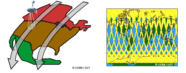
Many remote sensing platforms are designed to follow an orbit (basically north-south) which, in conjunction with the Earth's rotation (west-east), allows them to cover most of the Earth's surface over a certain period of time.
Most of the remote sensing satellite platforms today are in near-polar orbits, which means that the satellite travels northwards on one side of the Earth and then toward the southern pole on the second half of its orbit. These are called ascending and descending passes, respectively
As a satellite revolves around the Earth, the sensor "sees" a certain portion of the Earth's surface. The area imaged on the surface, is referred to as the swath. Imaging swaths for spaceborne sensors generally vary between tens and hundreds of kilometres wide. As the satellite orbits the Earth from pole to pole, its east-west position wouldn't change if the Earth didn't rotate. However, as seen from the Earth, it seems that the satellite is shifting westward because the Earth is rotating (from west to east) beneath it. This apparent movement allows the satellite swath to cover a new area with each consecutive pass. The satellite's orbit and the rotation of the Earth work together to allow complete coverage of the Earth's surface, after it has completed one complete cycle of orbits.
I've looked specifically into one sat tv company called dish network who is a spin off of Echostar. now if you examine the history you find they sold "sat tv" equipment long before they had satellites in orbit. The dishes (receive end) are fitted with LBN modules and don't point at a satellite. they point at a "satellite earth station" (send end) which uses a BUC module to convert the radio waves received by a satellite to a microwave signal.
so is land based microwave?
Now it does say the earth stations receive a signal from a satellite but is there another explination?
The way they claim orbit slots is a bit odd and it's possible to be using other methods such as balloons like "google loon" also things like this article http://www.nytimes.com/interactive/2015/12/29/world/countries-rush-for-upper-hand-antarctica.html?hp&action=click&pgtype=Homepage&clickSource=story-heading&module=photo-spot-region®ion=top-news&WT.nav=top-news talking about Antarctica and how Russia want to be there to improve their Glonass system which is their version of GPS. it talks about how Antarctica would improve coverage over the southern hemisphere. so
1) why would they nit have coverage over the southern hemisphere if satellites orbit and
2) why do they need land? Also look into AGPS technology on phones etc and flight tracking. now I can't prove anything with this but it is enough for me to question it especially when there are no pictures, videos and lots of cartoons. and hey if om wrong I learnt heaps. This is just the start of the info.
Aerostats
JLENS (Joint Land Attack Cruise Missile Defense Elevated Netted Sensor System) is rumored to be a $2.7B program and it couldn't even pick up the gyrocopter that landed in DC.
MUOS is a military Comms satellite arrangement. it always seems that the satellites are talking to a ground station and the ground station talks to the user. I guess this is due to Geostationary orbit but wouldn't you get a far better ground coverage from orbit height. I'll have to read up on the earth coverage beam which seems to be antennas used to provide "global coverage from a synchronous satellite" This makes me question further because wouldn't the curvature effect line of site to the ship etc? I'm certainly no expert and need to do a lot of reading on this but I can question it.
especially when it mentions the use of WCDMA which is land based cell towers but in this case the satellites supposedly replaces the towers. and of course run by Lockheed Martin who have a shady history.
I'd also like to plot the locations to see what area is covered.
https://en.m.wikipedia.org/wiki/Mobile_User_Objective_System
it replaced the UFO system https://en.m.wikipedia.org/wiki/UHF_Follow-On_System
which was the replacement for the FLTSATCOM https://en.m.wikipedia.org/wiki/Fleet_Satellite_Communications_System
there was also a few articles I read about troops in Afghanistan not being able to have remote communication and on ground comms had to be line of sight. couldn't the military afford a few sat phones?. maybe they were broke after spending $2B on a balloon lol. I could only find 1 below but I read a few.
This one talks about how they couldn't use balloons or planes to relay signals. 2001 ????
http://www.afcea.org/content/?q=troops-afghanistan-bridge-communications-gap-0
but there is a long history of balloons in the military for comms. why do they have to use balloons all the time? like the "tactical aerostats" http://m.military.com/NewContent/0,13190,Defensewatch_072105_Helms,00.html
Or spy planes to take images? and people wonder why we would be skeptical.
Lockheed Martin
Aerostats
Persistent threat detection system
http://www.lockheedmartin.com.au/us/100years/stories/ptds.html
http://www.lockheedmartin.com.au/us/news/press-releases/2014/october/isgs-1022-ptdsbordersurveillance.html
From afar, it looked like a scene straight out of an H. G. Wells novel. In 2003, a series of blimp-shaped air vehicles began rising, one after another, over the arid terrain of Afghanistan.
The unusual-looking ships—helium-filled aircraft called aerostats—rose to an altitude of 15,000 feet and floated quietly in the sky, each secured to a ground-based mooring system by long tethers.
Insurgents on the ground were perplexed by what they saw. The airships didn’t seem to move, nor did they fire missiles or release bombs.
It was only when insurgents began to notice coalition forces anticipating some of their covert operations that they realized those alien-looking airships had been watching—and recording—their every movement via a new surveillance program called the Persistent Threat Detection System (PTDS).
The Power of Persistence
Using aerostats for surveillance purposes has a long history, from the use of hot-air balloons during the Civil War to the recent deployment of tethered air vehicles to monitor drug-running activity in the Caribbean.
But in 2003, Lockheed Martin engineers began updating the envelopes of existing naval aerostats with new durable materials capable of achieving lift while carrying larger payloads of sensors, cameras and audio equipment. New tethers—lined with a mix of copper wires and fiber-optic cables—transmitted data to a Ground Control Station, which then disseminated near real-time information of hostile activity to operational forces.
The aerostats have proven to be an invaluable reconnaissance tool, gathering intelligence from 100 miles in every direction, 24 hours a day, for weeks on end, thwarting everything from the planting of IEDs in remote locations to rogue Afghan police officers extorting money from civilians at illegal checkpoints.
Many Eyes in the Sky
In all, some 66 PTDS aerostats have been put into action in Iraq and Afghanistan since 2003, as the program has evolved into a multi-mission surveillance platform equally adept at protecting convoys in transit as providing intelligence on enemy troop movements.
Due to the success of the PTDS aerostats, Lockheed-Martin is developing a High Altitude Long Endurance Demonstrator (HALE-D), which seeks to hover, completely untethered, at 60,000 to 70,000 feet. Used in conjunction with satellites and low-flying surveillance aircraft, these aerostats will offer multilayered surveillance capabilities, enhancing situational awareness in theaters of war while guarding U.S. and allied forces across the globe.
Using aerostats for surveillance purposes has a long history, from the use of hot-air balloons during the Civil War to the recent deployment of tethered air vehicles to monitor drug-running activity in the Caribbean. The aerostats have proven to be an invaluable reconnaissance tool, gathering intelligence from 100 miles in every direction, 24 hours a day, for weeks on end, thwarting everything from the planting of IEDs in remote locations to rogue Afghan police officers extorting money from civilians at illegal checkpoints.
Use in army PTDS
http://www.army.mil/article/82551/Army_accepts_last_Persistent_Threat_Detection_System_aerostat/
http://aeroscraft.com/aerostat/4575666089
US customs and boarder protection
https://www.cbp.gov/frontline/2014/10/frontline-november-aerostats
RAVEN AEROSTAR
Assisting Project loon
http://ravenaerostar.com/
Afghanistan
http://www.lockheedmartin.com.au/us/mst/features/110223-ptds--afghanistans-eyes-in-the-sky.html
TCOM
http://www.tcomlp.com/our-company/
Lockheed Martin
They literally run the sky
-looking after the GPS satellites.
http://www.lockheedmartin.com.au/us/products/gps.html
-built and delivered geostationary satellites for companies all over the world.
Will be responsible for the A2100 series sats the "work horse of global communication" like weather, government comms, new GPS sats etc.
-Launched satcom1 in 1975 which was the first geostationary sat..
This was responsible for the first TV network sat broadcasts
-Landsat earth images.
-Gravity probe relatively missions must read.
Talks about verifying "previously untested predictions of Einsteins theory and "by far the most accurate test of any of his theory" and
Being "one of few fundamental physic experiments from NASA"
-designed the Astronauts MMU
-designed star dust
-monitor 60% of the world's air traffic
But the main one i look at is
-Aerostat blimps
(which personally I think are the real satellites which is why they manage them all)
Might seem far fetched but Balloons were our first Communication "Satellites"
http://www.space.com/8973-1st-communication-satellite-giant-space-balloon-50-years.html
Used for missile defense system (PTDS)
http://www.lockheedmartin.com.au/us/products/lighter-than-air-vehicles/ptds.html
http://www.army-technology.com/projects/persistent-threat-detection-system-us/
one actually got loose once
http://www.foxnews.com/politics/2015/10/30/surveillance-balloon-program.html
This thing is what is NORAD uses to monitor for incoming missile attacks. Isn't that weird?
Were used for on ground communications with troops in areas where comms are limited like Afghanistan.
guess they can't use sat phones to communicate with, I don't know, ALL THE SATELLITES THEY HAVE ALL ORBITING THE EARTH.
This article talks about how they couldn't use balloons or planes to relay signals which they usually do.
http://www.afcea.org/content/…
There is a long history of balloons in the military for comms.
why do they have to use balloons all the time?
like the "tactical aerostats"
http://m.military.com/…/0,13190,Defensewatch_072105_Helms,0…
Why use spy planes to take images?
Why not just take a picture with a satellite?
Now if the military can't get a satellite signal do you think you do?
Originally teatherd to the ground
http://fas.org/nuke/guide/usa/airdef/tars.htm
but being developed into a HALE-D so it will hover untethered at 70k ft and "will be used in conjunction with low flying aircraft" for comms and monitoring.
Have you heard of "Google loon"
Facebook to use drones
i Think its odd to use a balloon or drone when we have all these satellites.
so many in Geostationary orbit that they are fighting over slots.
These disputes are addressed through the International Telecommunication Union's allocation mechanism.
https://en.m.wikipedia.org/wiki/Geostationary_orbit
So are there any slots left for new satellites?
http://www.satellitetoday.com/…/hot-orbital-slots-is-there…/
LORAN was a ground based GPS system used by the US military, deemed operational in 1943.
https://en.m.wikipedia.org/wiki/LORAN
So GPS could be a land based system.
Any evidence to support this?
Here is something interesting from the BEAR 1 balloon launch.
https://en.m.wikipedia.org/…/Balloon_Experiments_with_Amate…
"On May 27, 2000, this helium-filled balloon with a payload of .977 kg, was launched from the Bremner airport, and reached an altitude of 31,762 meters (104,206 feet).[4] This first flight was a test of the GPS receiver used, to ensure that the unit successfully reported location information above the 60,000 foot limit imposed upon manufacturers"
Why would GPS have a 60,000 ft limit if the satellite is above it?
Also look into plane tracking.
I hear all the time "planes are definitely tracked but i don't know.
what do you think?
One way only?
http://www.bbc.com/news/world-asia-pacific-26544554
And again.
http://www.cnbc.com/…/why-we-still-cant-track-an-airplane.h…
Can we?
Surely.......
http://www.technologyreview.com/…/could-passenger-planes-b…/
https://en.m.wikipedia.org/wiki/GPS_aircraft_tracking
ADS-B.
Still not in use.
https://en.m.wikipedia.org/…/Automatic_dependent_surveillan…–_broadcast
Also look into the MOUS-4
http://www.lockheedmartin.com.au/us/news/press-releases/2015/september/space-muos-4-launch.html
II haven't looked into this as much as i would have liked but its interesting how they are using a square of ground based stations which a few navy personnel have said the ships dishes point to.
https://en.m.wikipedia.org/wiki/Mobile_User_Objective_System
it replaced the UFO system
https://en.m.wikipedia.org/wiki/UHF_Follow-On_System
which was the replacement for the FLTSATCOM https://en.m.wikipedia.org/…/Fleet_Satellite_Communications…
the idea of satellite communication was proposed by Aurther C Clarke who actually wrote science fiction novels.
https://en.m.wikipedia.org/wiki/Arthur_C._Clarke
He first described this in a letter to the editor of Wireless World in February 1945 and elaborated on this concept in a paper titled Extra-Terrestrial Relays – Can Rocket Stations Give Worldwide Radio Coverage?, published in Wireless World in October 1945. The geostationary orbit is now sometimes known as the Clarke Orbit or the Clarke Belt in his honour.
Although there is also mention of earlier ideas from others about communication satellites but they did name the orbit belt after him.
The GPS patent
http://www.google.ca/patents/US5093800
and finally
corrosion in space
https://drive.google.com/file/d/0B3blzK7zrNRzVF9Oc1RyVHVHWWc/view