WELCOME TO MY SITE AND HERE IS MY DISCLOSURE
PLEASE VISIT "ABOUT THE SITE" FIRST AND THEN VISIT "RELIABLE INFORMATION".
MY INTENTION IS NOT TO PROVE ANYTHING. THE SITE IS JUST A PLACE TO SAVE MY RESEARCH AND CREATE AWARENESS OF THE TOPIC. I WANTED TO PROVIDE A RESOURCE TO EXPLAIN MY POINT OF VIEW TO FRIENDS AND FAMILY INSTEAD OF CONSTANTLY RETYPING AND PROVIDING LINKS. ALL REFERENCES ARE PROVIDED. DO NOT BELIEVE ME AND RESEARCH THE BELOW FOR YOURSELF.
IF SOMETHING IS MY OPINION I WILL STATE IT OTHERWISE I ATTEMPT TO JUST LAY OUT THE INFORMATION FOUND. I MAY ON OCCASION PROVIDE MY CONCLUSION AT THE END BUT ULTIMATELY ITS UP TO YOU MAKE YOUR OWN JUDGEMENT.
USE DISCERNMENT WHEN READING ANY INFORMATION SOURCE.
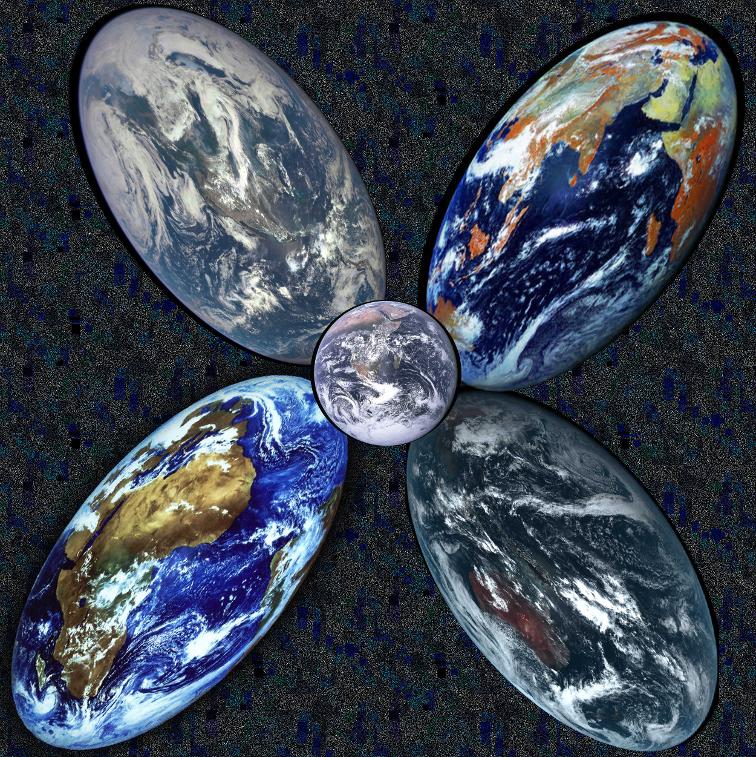
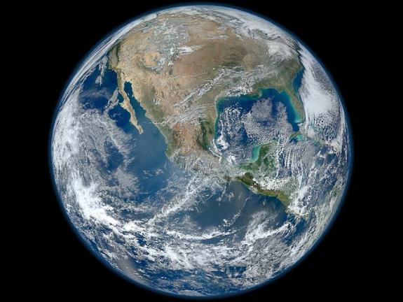
Pictures of Earth
HISTORY / TIMELINE
If you have ever debated with a Flat Earther you would have surely heard them use the argument "All of the pictures of earth are fake".
This may seem like a ridiculous argument.......But have you ever really examined one?
When I heard that people thought the Earth is flat the pictures seemed like the most logical place for me to start.
What did I find?
Below will be a work in progress.
I will simply add all of the "pictures" I come across in the order they were taken. Initially I intended on just providing the picture and link but I found that a little commentary went a long way in making any "Ball Earther" question themselves.
May be in a rough format for now but I will Tidy up along the way.
Fell free to copy any images you may find interesting.
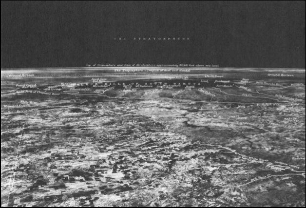
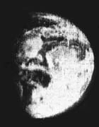
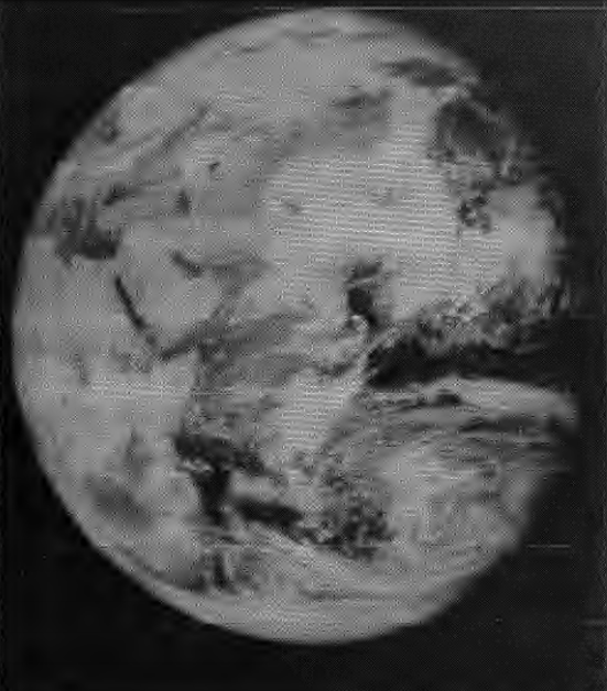
November 11th, 1935
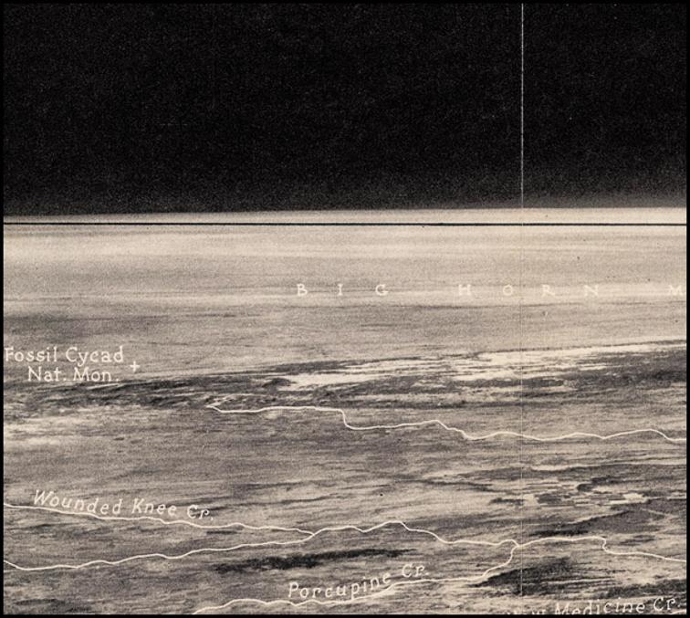
Below is the first image of Earth taken from the Stratosphere and the first to show curvature.
UPDATE 23/6/16- Original link was
Source - Michigan Sate University
http://blogpublic.lib.msu.edu/index.php/on-display-this-week-the-1?blog=55
Which is now broken but I managed to find the image from the same source by searching fror "On display this week" from MSU's home apge search bar
RESULT PAGE - https://search.msu.edu/index.php?q=on+display+this+week#gsc.tab=0&gsc.q=on%20display%20this%20week&gsc.page=1
NEW SOURCE BELOW
Source - Michigan Sate University
https://blogs.lib.msu.edu/map-library/2013/may/display-week-curvature-earth/
Captains A.W. Stevens and O. A. Anderson ascended from Rapid City, South Dakota, in the 3,700,000 cubic feet rubberised cloth helium balloon Explorer II (not to be confused with Explore 2 which was a rocket launch in 1958) at 4 a.m. on November 11, 1935. The balloon reached an altitude of 72,395 feet (13.71 miles) at 10:50 and remained there until 12:20 p.m. The balloon made a perfect controlled landing 125 miles away near White Lake, South Dakota after 8 hours 13 minutes. A photograph taken at the peak of the ascent was the first to show the curvature of the Earth, with a horizon over 300 miles distant.
The new manned flight altitude record they established remained for 21 years, until in 1956 Air Force pilot Captain Ivan Kincheloe shattered it by flying a Bell X2 to a height of 126,200 feet (38,465 meters).
StratCat story of Both Explorer Balloons
http://stratocat.com.ar/artics/explorer-e.htm
and the "Permalink" is below
https://blogs.lib.msu.edu/node/225981/
I found the MSU article to be far more interesting than the picture. I Came across this MSU site with picture (below) on a Flat earth Facebook group. Someone had posted it as a proof of a Ball Earth.
Firstly, It was the first time a human had been high enough to take a Picture that actually showed curvature.
Bare in mind that this is 1935. We "knew" the earth was a ball for (some say) thousands of years, even though at this point we had only theorized, made observations and calculated the shape of the Earth. There was no visual proof, and for many seeing is believing. And there it is right?
The article says
"Certainly by 1936 practically everyone understood that the Earth is a sphere (or, more accurately, a slightly irregular geoid). Two U.S. Army Air Corp Captains were able to provide Earthlings with definitive proof by venturing 72,395 feet above the Earth to take this photograph. The black horizontal line, when compared to the Earth’s horizon, shows the curvature.
This aerial photomap also revealed the novelty of a black sky (due to only 4% of the Earth’s atmosphere being above their balloon, the Explorer II).
Also on display we have a booklet forwarding the idea of a Flat Earth. Since ardent Flat Earth proponents are mostly uninterested in science-based evidence, the photograph hardly rained on their parade at all.
These items will be on display in the MSU Map Library the week of May 6, 2013. The map was a generous gift of Ron Dietz. The booklet was purchased from funds provided through the Brunnschweiler Geography Library Endowment Fund."
The curve is pointed out by the black line.
So not that I want to be one of those people that are "uninterested in science-based evidence", well mostly..... I drew my own straight red line on the image and besides a little bit of horizon blur it would appear that the line matches the flat horizon.
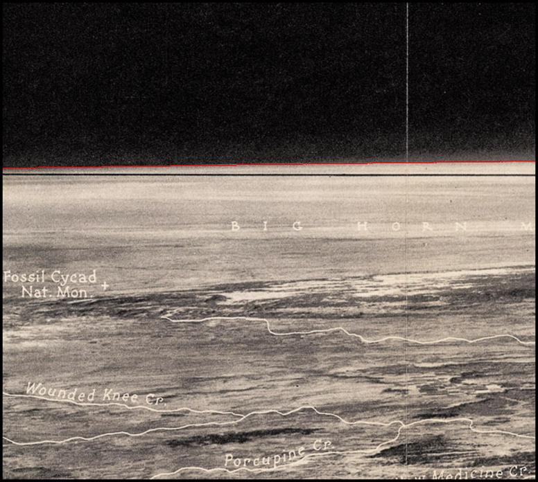
The comparison can be seen below
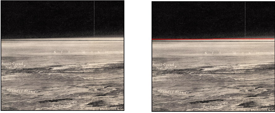
While drawing my line I also took some measurements using GIMP 2.0 and the black line is exactly 350 pixels from the bottom edge of the image on each side, so it runs perfectly horizontal.
The horizon is at an angle.
So the Image on MSU’s site that is used to show the Earths curvature and that flat Earthers are ridiculed due to their refusal to accept scientific evidence is a simply a black line drawn perfectly horizontal through the image with slanted horizon which is 0.66 degrees off horizontal.
I found the number very coincidental. I’m pretty confident that if GIMP showed the value to 3 decimal places it would have been 0.666 degrees.
I took a screen recording of this process to help show that the image has not been altered and i will add it below when I am ready to load my videos to the new site Youtube channel.
It has been many months since i revisited this image. I have acquired many tools along the way which helped me identify a few other interesting things this time which have also been included in the video.
add video here
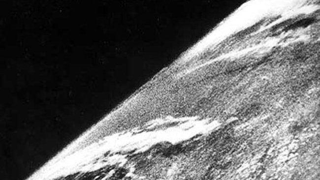
So this leads to this image.
As mentioned The MSU image was not the first one I had seen.
It can be seen to be the same landscape but with a much wider view.
Why would this image not be used originally?
http://www.phenomena.org.uk/features/page139/page139.html
October 24th, 1946
First Picture from Near Earth Orbit (NEO)
The first picture of Earth from near Earth Orbit was taken from a V2 Rocket
V2 Rocket and some other information from Marshall Space Fight Center (MFSC) here
The V-2 research program moved fairly quickly, with flights scheduled at the White Sands Proving Ground, New Mexico. The first static engine test firing of a German V-2 on U.S. soil occurred on March 14, 1946. The missile used for this engine test became the first German V-2 launched in the U.S. on April 16, 1946. The U.S. V-2 series of launches concluded in 1952.
Some of the launches employed V-2 missiles equipped with scientific instrumentation designed to study the upper atmosphere. These types of V-2 launches were managed by the V-2 Upper Atmosphere Research Panel, which was established in January, 1947 and evolved into the Upper Atmosphere Rocket Research Panel in March, 1948.
Source for the history of rocketry
http://www.spaceline.org/history/6.html
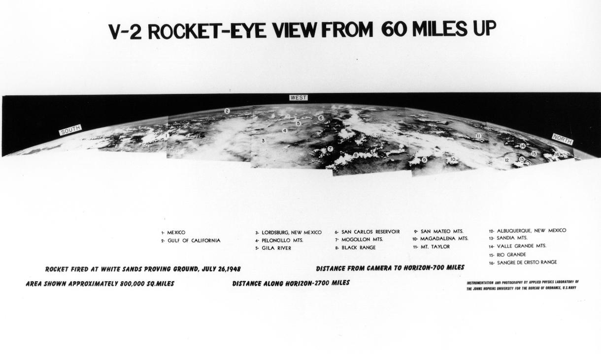
Below is the first picture of Earth taken in near earth orbit at 65 Miles high by the V-2 #13 rocket launched from White Sands Missile range (WSMR) on October 24th 1946 during "Small Steps Program"
http://www.airspacemag.com/space/the-first-photo-from-space-13721411/?no-ist
"Snapping a new frame every second and a half, the rocket-borne camera climbed straight up, then fell back to Earth minutes later, slamming into the ground at 500 feet per second. The camera itself was smashed, but the film, protected in a steel cassette, was unharmed.
Fred Rulli was a 19-year-old enlisted man assigned to the recovery team that drove into the desert to retrieve film from those early V-2 shots. When the scientists found the cassette in good shape, he recalls, "They were ecstatic, they were jumping up and down like kids." Later, back at the launch site, "when they first projected [the photos] onto the screen, the scientists just went nuts."
More than 1,000 Earth pictures were returned from V-2s between 1946 and 1950, from altitudes as high as 100 miles. The photos, showing huge expanses of the American southwest, appeared in newspapers and were scrutinized by scientists from the U.S. Weather Bureau. In his National Geographic article
http://www.astronautix.com/lvs/v2.htm
1946 October 24 - . 19:15 GMT - . Launch Site: White Sands. Launch Complex: White Sands LC33. LV Family: V-2. Launch Vehicle: V-2. LV Configuration: V-2 13.
- Solar ultraviolet / chemical release mission - . Nation: USA. Agency: USA; APL. Apogee: 105 km (65 mi). Launched 12:18 local time. Reached 104.8 km. Carried cosmic and soalr radiaiton, winds, photography experiments for Applied Physics Lab, John Hopkins University. The John Hopkins camera took motion pictures of the earth at over 100 km altitude (pictures covered 100,000 square km.)
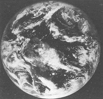
The Following image is a series of pictures stitched together to make a panorama.
http://www.nasa.gov/multimedia/imagegallery/image_feature_1298.html
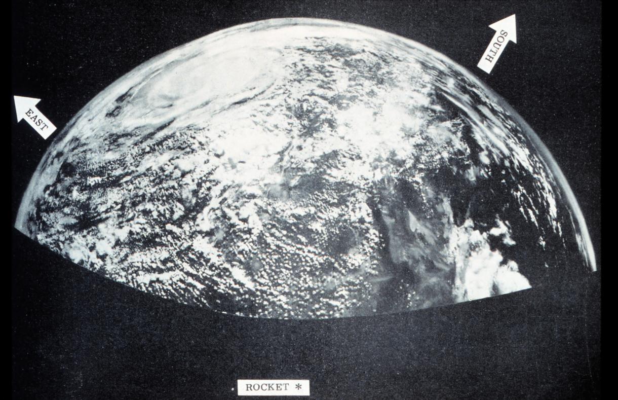
"On March 7, 1947, not long after the end of World War II and years before Sputnik ushered in the space age, a group of soldiers and scientists in the New Mexico desert saw something new and wonderful in these grainy black-and-white-photos - the first pictures of Earth as seen from altitude greater than 100 miles in space. Just the year before in 1946, scientists like John T. Mengel, a NASA pioneer who later oversaw the Vanguard Program, began experimenting with captured German V-2 rockets.
Mengel conducted upper atmosphere experiments by launching the rockets into near-earth orbit. He designed and fabricated the first research nose shell to replace of the V-2 warhead and began placing cameras in the nose shell.
Before the Small Steps Program began in 1946 using V-2 rockets to take images from space, the highest pictures ever taken of the Earth's surface were from the Explorer II balloon, which ascended 13.7 miles in 1935, high enough to discern the curvature of the Earth. The V-2 cameras reached more than five times that altitude and clearly showed the planet set against the blackness of space. When the movie frames were stitched together, the panoramas taken in the late 1940s covered a million square miles or more at a single glance."
The following is the same set of images making the full panorama
http://media.airspacemag.com/images/V2-panorama.jpg
On 24th May 1954 the Viking 11 rocket at an altitude of 159 miles.
On October 5, 1954, during a launching over New Mexico, a camera mounted in an NRL Viking rocket took the first picture of a hurricane and a tropical storm, from altitudes as high as 100 miles. The picture embraced an area more than 1000 miles in diameter, including Mexico and the area from Texas to Iowa. This was also the first natural-color picture of Earth from rocket altitudes. The success NRL achieved in this series of experiments encouraged Laboratory scientists to believe that, with a more powerful engine and the addition of upper stages, the Viking rocket could be made a vehicle capable of launching an earth satellite.
This led to NRL's Vanguard project.
http://www.nrl.navy.mil/accomplishments/rockets/viking-program/
http://www.astronautix.com/lvs/viking.htm
The First Image from space taken from Explorer 6 on 14th August 1959.
It shows a sun-lighted area of the Central Pacific ocean and its cloud cover. The picture was made when the satellite was about 17,000 miles above the surface of the earth
https://commons.wikimedia.org/wiki/File:First_satellite_photo_-_Explorer_VI.jpg
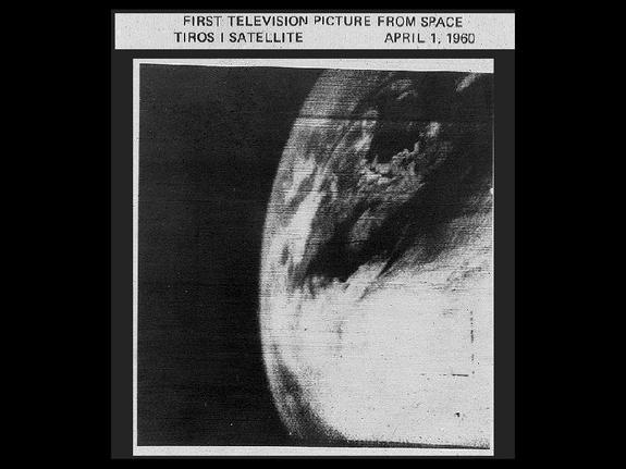
Below is the first photo of Earth from a weather satellite, taken by the TIROS-1 satellite on April 1, 1960. Early photographs provided new information on cloud systems, including spiral formations associated with large storms, immediately proving their value to meteorologists
http://www.space.com/20759-earth-from-space-nasa-photos.html
The first crude television image of the distant Earth as a planet in space was made by a Soviet weather satellite on May 30, 1966
http://www.donaldedavis.com/2003NEW/NEWSTUFF/DDEARTH.html
The Suomi NPP satellite has become a workhorse of Alaska (and global) meteorology. The satellite is named for Verner Suomi, often referred to as the “father of satellite meteorology”.
Suomi and UW-Madison colleague Robert Parent designed the Spin-Scan Cloud Camera flown on the ATS-1 satellite in 1966. Meteorology was forever changed by that mission.
ATS-1's image of Earth and the moon together, taken Dec. 22, 1966, was the first of its kind
http://uafgina.tumblr.com/post/57547267354/verner-suomi-the-father-of-satellite-meteorology
http://www.nasa.gov/centers/goddard/missions/ats.html
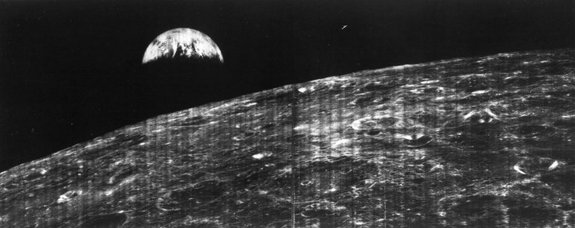
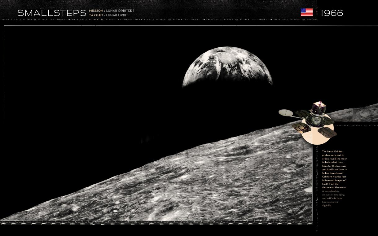
In August 1966 NASA began the Lunar Orbiter series of missions that were intended to get up-close images of smooth areas of the moon suitable for landing both Surveyor unmanned lander probes as well as the eventual manned missions of Apollo
This first Lunar Orbiter mission is credited for returning the first 2 images of Earth as seen from the distance of the moon. Most people refer to these kinds of images as “Earthrise” images.
http://wanderingspace.net/cat/smallsteps/
The one below is the original taken 23rd August 1966. Unlike today’s digital photography, images were made on film, which was developed automatically onboard, much like how a Polaroid camera works, before being scanned, digitized and sent to Earth via radio signals. (Source)
The Second is Digitally edited (Source)
Although most people have come to associate the first picture of the "Whole Earth" with the Apollo program, Lunar Orbiter V actually captured this awesome view of the home planet. When this picture (L-67-6777) was taken on 8 August 1967, the spacecraft was about 5860 kilometers {3641.2 miles) above the moon in near polar orbit, so that the lunar surface is not seen .. Clearly visible on the left side of the globe is the eastern half of Africa and the entire Arabian peninsula.
Source
SPACEFLIGHT REVOLUTION NASA Langley Research Center From Sputnik to Apollo by James R. Hansen
http://history.nasa.gov/SP-4308.pdf
Earth was first shown as a disk in color by the Department Of Defense Gravity Experiment satellite (DODGE) operating between July and November 1967. This image was captured on September 20. At the bottom can be seen a boom with a color target, a painted sphere. From John Hopkins Applied Physics Lab, who painted the color ball and produced this image.
On November 16-17 the satellite tumbled out of control, possibly from the impact of a Leonid meteor.
http://www.donaldedavis.com/2003NEW/NEWSTUFF/DDEARTH.html
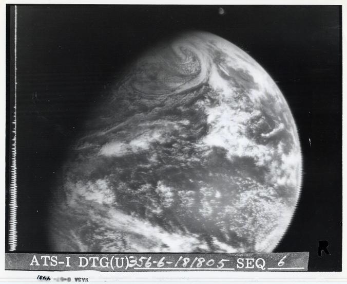
The ATS-1 satellite was used in 1967 to make the first full disk animated movie of global weather from a time-series of black-and-white still photographs placed sequentially on a film stand.
http://goes.gsfc.nasa.gov/text/goesnew.html
check this time line
Below is aFull-disc photograph of the earth from equatorial orbit, transmitted by ATS 3 on 10 November 1967. A cold front moves eastward over the central United States and a tropical storm is a bottom center.
http://history.nasa.gov/SP-4402/ch2.htm
High definition color television images of the Earth as a disk were first obtained by the U.S. Applications Technology Satellite, this early example taken on November 18, 1967.
From the NASA SP 'Exploring Space With A Camera'
http://www.donaldedavis.com/2003NEW/NEWSTUFF/DDEARTH.html
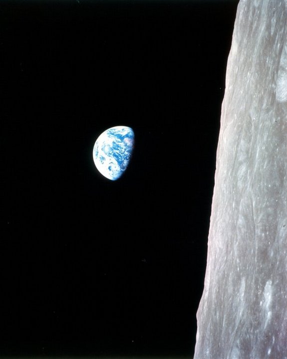
This view of the rising Earth greeted the Apollo 8 astronauts as they came from behind the moon after the lunar orbit insertion burn.
The photo, taken 24th December 1968 is the first of its kind and know as "Earth Rise". It is in its original orientation, though it is more commonly viewed with the lunar surface at the bottom of the photo. Earth is about five degrees left of the horizon in the photo. The unnamed surface features on the left are near the eastern limb of the moon as viewed from Earth. The lunar horizon is approximately 780 kilometers from the spacecraft. The height of the photographed area at the lunar horizon is about 175 kilometers.
http://www.livescience.com/20369-earth-pictures-space.html
The below was also taken on the Apollo 8 mission.
Showing South America nearly covered with clouds and the brown Sahara withdrawing into the night.
http://www.donaldedavis.com/2003NEW/NEWSTUFF/DDEARTH.html

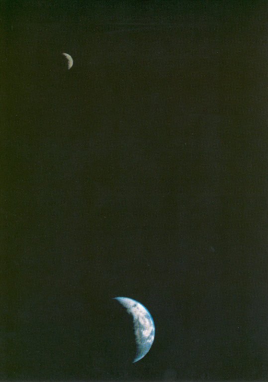
On August 8, 1969 while on its way to the Moon, Zond 7 obtained excellent color photography of the Earth at a distance of about 70,000 km..
This seldom seen full Earth photo was digitally restored from a badly faded print.
http://www.donaldedavis.com/2003NEW/NEWSTUFF/DDEARTH.html
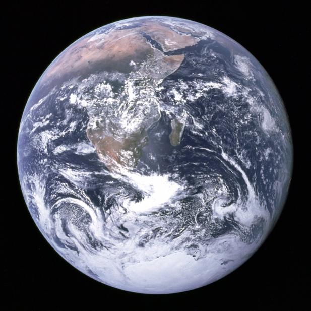
"The Blue Marble" was the first full view picture of Earth.
Taken from Apollo 17 in 1972
This NASA picture of the Earth and the moon in a single frame, the first of its kind ever taken by a spacecraft, was recorded Sept. 18, 1977, by Voyager 1 when it was 7.25 million miles (11.66 million kilometers) from Earth. The moon (top) is beyond the Earth as viewed by the space probe. Because the Earth much brighter than the moon, the moon was artificially brightened by a factor of three by computer enhancement so that both bodies would show clearly in the image.
http://www.livescience.com/20369-earth-pictures-space.html
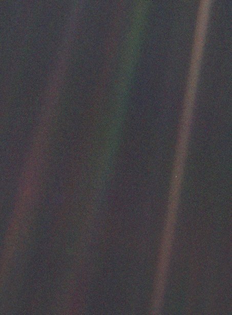
The "Pale Blue Dot" image , taken 14th February 1990 is a part of the first portrait ever made of our solar system from 6 Billion km (3.7B Miles), taken by Voyager 1.
Voyager acquired 60 frames for a mosaic of the solar system from more than 4 billion miles from Earth and about 32 degrees above the ecliptic — the plane in which most of the planets orbit. Earth is just below and right of center, smack in the middle of one of the scattered light rays resulting from taking the image so close to the sun.
http://www.livescience.com/20369-earth-pictures-space.html
This amazing image below was taken by the Galileo spacecraft as it flew by the Earth-Moon system on its way to Jupiter in 1992.
http://www.livescience.com/20369-earth-pictures-space.html

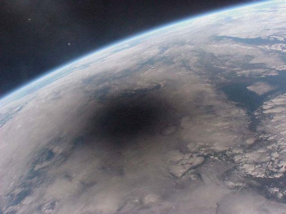
During a solar eclipse, the shadow of the moon moves across Earth’s surface at nearly 2,000 kilometers per hour as the eclipse unfolds. This picture of the Aug. 11, 1999, solar eclipse was one of the last ever taken from the Russian Mir space station.
When we experience a solar eclipse, the moon blocks out the sun. But from space, looking down on our planet, the event takes on an entirely different perspective. We see a strange blemish on our world — the shadow of the moon falling on the planet’s surface. This picture reveals why everyone on Earth is not able to see any given total solar eclipse — the shadow covers just part of the planet, and you have to be near the center of the shadow to experience the eclipse.
http://www.livescience.com/20369-earth-pictures-space.html
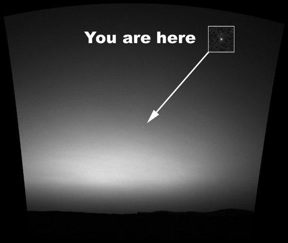
Below is the first image of Earth made from the surface another planet. It was taken by the Mars Exploration Rover Spirit on March 8, 2004, an hour before sunrise, with the surface of Mars in the foreground. The contrast was doubled to make Earth easier to see.
http://www.livescience.com/20369-earth-pictures-space.html
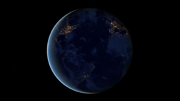
The image below is known as the ‘Black Marble’ composite image was taken by the Suomi NPP satellite in April 2012, showing the Earth lit up at night by a mixture of artificial lights and the Sun.
http://www.livescience.com/20369-earth-pictures-space.html
The latest "Blue marble" series
NASA has produced several Blue Marble images. The original, taken by the crew of Apollo 17, shows the Eastern Hemisphere and is thought to be one of the most famous and widely distributed images of Earth ever. Below, one of the most recent Blue Marble images was created by stitching together satellite imagery and reveals the Western Hemisphere in all its glory. The first pictures from space were not nearly as routine as the Blue Marbles are now.
Taken from the VIIRS instrument aboard NASA's most recently launched Earth-observing satellite, Suomi NPP. This composite image uses a number of swaths of the Earth's surface taken on Jan. 4, 2012.
http://www.livescience.com/20369-earth-pictures-space.html
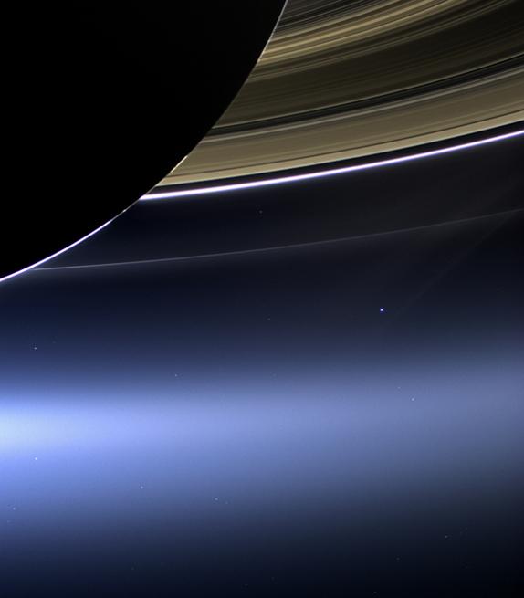
NASA’s Cassini spacecraft snapped this view of Saturn's rings, with Earth way, way off in the distance, using a wide-angle lens on July 19, 2013. You’re looking at the dark side of Saturn, its bright limb, the main rings, plus the F, G and E rings.
http://www.livescience.com/20369-earth-pictures-space.html
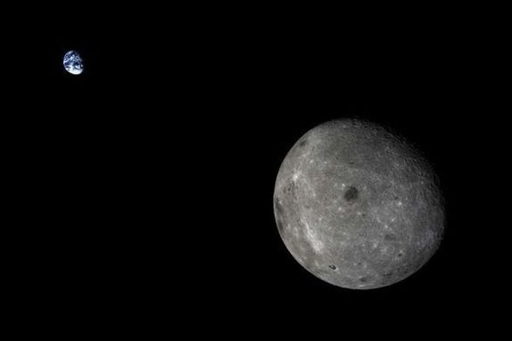
China launched its fourth mission to the moon in October 2014, sending a probe to loop around the moon and return to Earth. Along the way, the probe captured a classic view of our world over the moon’s shoulder.
The lunar-loop mission that generated this picture is one step toward China’s planned Chang'e 5 sample-return mission in 2017.
http://www.livescience.com/20369-earth-pictures-space.html
To research
https://en.wikipedia.org/wiki/Project_Vanguard
Project Vanguard was a program managed by the United States Naval Research Laboratory (NRL), which intended to launch the first artificial satellite into Earth orbit using a Vanguard rocket[1] as the launch vehicle from Cape Canaveral Missile Annex, Florida.
In response to the surprise launch of Sputnik 1 on October 4, 1957, the U.S. restarted the Explorer program, which had been proposed earlier by the Army Ballistic Missile Agency (ABMA). Privately, however, the CIA and President Dwight D. Eisenhower were aware of progress being made by the Soviets on Sputnik from secret spy plane imagery.[2] Together with the Jet Propulsion Laboratory (JPL), ABMA built Explorer 1 and launched it on January 31, 1958. Before work was completed, however, the Soviet Union launched a second satellite, Sputnik 2, on November 3, 1957. Meanwhile, the spectacular televised failure of Vanguard TV3 on December 6, 1957 deepened American dismay over the country's position in the Space Race.
On March 17, 1958, Vanguard 1 became the second artificial satellite successfully placed in Earth orbit by the United States. It was the first solar-powered satellite. Just 152 mm (6 in) in diameter and weighing just 1.4 kg (3 lb), Vanguard 1 was described by then-Soviet Premier Nikita Khrushchev as, "The grapefruit satellite."[3]
Vanguard 1 is the oldest artificial satellite still in space, as Vanguard's predecessors, Sputnik 1, Sputnik 2, and Explorer 1, have decayed from orbit.
The Vanguard 1 radio continued to transmit until 1964, and tracking data obtained with this satellite revealed that Earth is not quite a perfect sphere: it is slightly pear-shaped, elevated at the North Pole and flattened at the South Pole. It corrected ideas about the atmosphere's density at high altitudes and improved the accuracy of world maps. The Vanguard program was transferred to NASA when that agency was created in mid-1958. Add this to the shape of earth
Vanguard 2 used to verify earth "pear shape"
http://www.nrl.navy.mil/accomplishments/rockets/vanguard-project/
Project Excelsior- High altitude jumps 1959-60
Such balloons were used for scientific research, most notably in the US Navy's SKYHOOK program,
Look at MOGUL(excuse fro roswell as it was a secret balloon program in 1947'
GOPHER was used to spy on USSR
MOBY DICK IN 1953 TO MAP HIGH ALTITUDE WIND CURRENTS
FLYING CLOUD used for a hydrogen filled attack balloon, like chemical or bio agents
GRANDSON for high alt photo reconosnce
source for "cold war balloon fights" to cover this section of orange text is below
http://www.airvectors.net/avbloon_3.html
Project Echo- balloon sat
http://history.nasa.gov/SP-4308/ch6.htm
Explorer 1- First US sat